Colonizing New Lands: Rural Settlement of Refugees in Northern Greece (1922–40)
Pages 140 to 167
Cite this article
- HASTAOGLOU-MARTINIDIS, Vilma
- and PALLINI, Cristina,
- Hastaoglou-Martinidis, Vilma.
- et al.
- Hastaoglou-Martinidis, V.
- and Pallini, C.
https://doi.org/10.3917/clara.008.0140
Cite this article
- Hastaoglou-Martinidis, V.
- and Pallini, C.
- Hastaoglou-Martinidis, Vilma.
- et al.
- HASTAOGLOU-MARTINIDIS, Vilma
- and PALLINI, Cristina,
https://doi.org/10.3917/clara.008.0140
Notes
-
[1]
Muslims from Crimea and Caucasus were resettled in Rumelia and the Danube regions, all of which were then part of the Ottoman Empire. An Immigration Commission (1860) from the Ministry of Trade oversaw the planning of rural villages for refugees. The Russo-Turkish War resulted in an additional two million refugees. A new Immigration Commission enacted nationwide regulation: refugee villages were to be located along roads and railways (existing or planned) following a grid layout and including a school and mosque. Villages built by migrants, however, outnumbered those planned and built by the state.
-
[2]
From 1912 to 1913, over 100,000 Turks left the Balkans to resettle in regions that were still part of the Ottoman Empire; 15,000 Bulgarians followed their retreating army, while 10,000 Greeks left the Serbian and Bulgarian parts of Macedonia. The Bulgarian occupation of Western Thrace resulted in the expulsion of 70,000 Greeks and 48,470 Muslims, who were replaced by 46,764 Bulgarians from Eastern Thrace. In 1914, the Young Turks expelled 350,000 Greeks from Eastern Thrace and the coast of Asia Minor: 85,000 were deported to the interior of Turkey, leaving 265,000 to seek refuge in Greece. Concurrently, 115,000 Muslims left Greece, and 135,000 left other Balkan countries (Pentzopoulos, 1962: 24–51).
-
[3]
All Greek Orthodox of Turkey, except those living in Istanbul, had to leave, as did Muslims of Greece except those of Western Thrace. Circa 300,000 Greeks had left Asia Minor from 1918 to 1922, and an additional 800,000 in the wake of the Smyrna fire, leaving only 200,000 to be moved under the terms of the Lausanne Peace Treaty (Devedji, 1929: 9–62); 355,000 Muslims, most of whom from Macedonia, were moved to Turkey (Kritikos, 2005: 332).
-
[4]
US diplomat Henry Morgenthau Sr (1856–1946) was the first chairman, other members included John Campbell (1874–1944) of the Indian Civil Service (and representative of the Bank of England), and the Greeks Pericles Argyropoulos (1881–1966) and Stefanos Deltas (1863–1947). The following RSC chairmen were Charles P. Howland (1869–1932) and Charles B. Eddy (1872–1951).
-
[5]
Michalis Notaras (1934: 12), an RSC employee and later high ranking official of the Agricultural Bank of Greece, left a comprehensive account of the new rural colonies. The slightly diverging figures provided by Dimitri Pentzopoulos (1962: 107) are based on the 1930 population census, which reported a total number of 145,758 rural families (578,824 individuals) settled throughout Greece, of which 87,170 (339,094 individuals) in Macedonia and 42,790 (170,060 individuals) in Thrace.
-
[6]
The remaining 56,738.7 ha were located in other provinces (Howland, 1926: 86).
-
[7]
The average cost for each family was projected to be ₯ 41,140 (£152), broken down as follows: ₯ 18,000 for the house; ₯ 8,000 for two oxen; ₯ 2,000 for subsistence allowance; ₯ 1,500 for seed; ₯ 400 for a harness; ₯ 1,500 for forage; ₯ 300 for a plough; ₯ 200 for other implements; ₯ 5,500 for a cart and ₯ 3,740 for general expenses (Grinnell Mears, 1929: 295).
-
[8]
Mostly mountain villages at the border of Macedonia and Thrace inhabited by pastoral refugees from Pontus.
-
[9]
Eleftherios Venizelos (1864–1936) and his liberal government played a key role until 1932, firmly supporting the dynamism of the middle class as the cornerstone of modern Greek society.
-
[10]
Karamanos (1891–1966) studied at the Agricultural High School of Portici near Naples, where he possibly got acquainted with prominent Italian agronomists, such as Emanuele De Cillis and Alberto De Dominicis, who envisaged the possibility of increasing wheat productivity in Southern Italy. Henry Morgenthau (1929: 270–2) praised Karamanos’s work for the GDCM. After the liquidation of the RSC, Karamanos was appointed Director-General in the Ministry of Agriculture, in the Venizelos administration, and served during 1929–32 (Karamanos, 2020).
-
[11]
Only ten dispensaries were housed in existing structures, the remaining forty-three were new buildings constructed for the purpose.
-
[12]
The Italian term condotta designated the contract between a village and a general practitioner, who was to provide medical care exclusively to the families living there. Applied in many of the new villages, the system reinforced the solidarity bonds of the new communities (Metallinos, 1931: 397–457).
-
[13]
This was a relatively low amount if compared to the expenditure of £650 for each of the 1,438 families in the fifty-eight settlements (though of a much better quality) established by Zionists in British Palestine, or to the £250 per family for the refugees in Bulgaria during the same period (Hope Simpson, 1929; Notaras, 1934: 42).
-
[14]
Many existing villages had some housing, formerly occupied by Muslims, who were evacuated, available for refugees, though many had been destroyed during the previous decade of war (Notaras, 1934: 12–13). Different sources report different figures, mostly because some new villages were abandoned and/or relocated by their inhabitants.
-
[15]
By the end of 1930, there were 477 aqueducts covering 750 km, 508 artesian wells and 648 common wells (Hope Simpson, 1929: 590).
-
[16]
Special decrees issued from 1923 to 1926 addressed these problems (Kontogiorgi, 2006: 125–6).
-
[17]
Areas for cereal cultivation had an average extension of 2.91 ha per family, those for tobacco only 1.70 ha (Notaras, 1934: 48).
-
[18]
The death of the concessionaire brought the scheme to a halt (Pennas, 1976).
-
[19]
The firm was based at 3, Victoria Street, Westminster (Labrum, 1994: 54). Of Danish descent, Walter Robert Kinipple (1832–1901) was an expert in marine and railway works and in the use of Portland cement and dredging machines. He also examined the Damietta and Rosetta Dams of the Nile and the Shubrah Locks for the Egyptian Government (Grace’s Guide…, 2022).
-
[20]
The Modiano family, among others, owned large farms in the area – in Topsin and Nisi – whereas Abbott Bros built a fortune based on the trade of leeches fished in the Giannitsa Swamp (Gefyra, 2004; Clark, 2021).
-
[21]
From 1928 to 1935, Technika Chronika (Technical Annals) and Technikí Epetirís tis Elládos (Technical Yearbook [of the Technical Chamber of Greece]) provided extensive coverage of reclamation works in Macedonia.
-
[22]
A soil engineer and senator, Prampolini (1876–1959) played a leading role in the reclamation of the Pontine Marshes and other areas (Reggio Emilia, Southern Italy), and worked as an expert in Albania, Bulgaria and Romania.
-
[23]
According to another estimate, 82,700 ha were recovered by the drainage of swamps and lakes, 177,400 ha were improved by drainage, 107,500 ha were protected from flooding, and 27,400 ha were irrigated (Greek Ministry of Communications…, 1958).
-
[24]
The Higher Agricultural School of Athens, staffed by prominent agronomists involved in the colonization of Northern Greece, was initially established as an independent higher education institute; it was renamed the Agricultural University of Athens in 1989. (“The history of the AUA”, n.d.)
-
[25]
According to Polyzos (1947: 97), 37% of the farms were of 0.1 to 1 ha; 35% of 1 to 3 ha; 23% of 3 to 10 ha; 3.7% of 10 to 60 ha; and only 0.23% of 60 to 30,000 ha.
-
[26]
E. Kypriadis (1887–1958) was born in a wealthy family in Alexandria (Egypt) and studied agronomy in Belgium at the State Agronomic Institute of Gembloux. In 1928 he took over the Directorate of Agricultural Applications of the Ministry of Agriculture, expanding mechanization, founding the Service of Mechanical Cultivation and modelling private farms. Kypriadis taught agricultural engineering at the Higher Agricultural School of Athens from 1926 to 1958 (“Epameinondas Kypriadis”, 1958).
-
[27]
With the Treaty of Versailles (1919) Danzig, today’s Gdansk (Poland), was separated from the German Reich, and acquired the status of Free City of Danzig, with a port on the Baltic Sea under the protection of the League of Nations (until 1939).
-
[28]
Adolf Sommerfeld, who was born in 1886 in Kolmar in Posen (today’s Chodzież, Poland) and died in 1964 in Baden, Switzerland, ran the Allgemeine Häuserbau-Actien-Gesellschaft (AHAG) construction company in Berlin, where he also collaborated with Walter Gropius and Adolf Meyer (Sommerfeld House, 1920–21), Richard Neutra (project for the Sommerfeld Houses, 1923; Bürgerhaus quarter, 1930s), and Bruno Taut (Großsiedlung Onkel Toms Hütte, 1926–32). In 1923, Sommerfeld worked on a housing development on Mount Carmel (Haifa, British Palestine) in collaboration with Erich Mendelsohn and Richard Kauffmann. In 1933, to escape persecution owing to his Jewish origin, he moved to Switzerland and thence to France. In 1935, he emigrated to British Palestine and, in 1938, to Great Britain, where he acquired British citizenship. After 1945, he resumed his construction business in Berlin (Kress, 2011: 239–41).
-
[29]
Alfréd Forbát (1897 Pécs, Hungary–1972 Vällingby, Sweden) was trained at the University of Budapest and at the Technical University of Munich. For AHAG (see note 28), Forbát drew up the plan of Zehlendorf-West AG, which brought him into contact with Bruno Taut (1880–1938, German architect), Otto Rudolf Salvisberg (1882–1940, Swiss architect) and Hugo Häring (1882–1958, German architect) (Forbát 2019, 91–92). His collaboration with Sommerfeld continued until 1928 as chief architect of AHAG. In 1926, Forbát joined the association of progressive architecture Der Ring (1926–33). In Berlin, he worked at the Ringsiedlung Siemensstadt Housing Project (1929–31) and at the multipurpose Mommsenstadion (1930). In 1933, he joined the Ernst May Brigade in the USSR, working on government housing projects. That same year, after an exploratory journey to Athens that included attendance at the fourth CIAM meeting, Forbát returned to Hungary, then emigrated to Sweden in 1938. During the 1940s and 1950s, he concentrated on urban planning, which he taught at the Stockholm Royal Institute of Technology (1959–60) (Atuul limited, n.d.; Park, 2014).
-
[30]
Some of these buildings remain, in the villages of Nea Pella, Nea Axos and Aravissos. Houses of the third type were built in the colony of Nea Menemeni, west of Thessaloniki.
-
[31]
Sick and weak as they were, refugees often covered the timber skeletons with a tent, so DHTG had to protect them with a provisional outer layer of cement raffia or wooden boarding. Additional problems concerned transport: timber arrived by steamer and was numbered according to type; it was unloaded at the huge GDCM storage facility on the shore west of the port, next to Beşçinar Garden (“The government and…”, 1924), where it was bundled according to type. The Colonization Department was to deliver kits to sites by lorry or railway, yet in many cases nothing arrived. Challenging a clause in the contract, DHTG took over the transport, buying five trucks from the American army and setting up a carpentry workshop by the storage facility to cope with any unforeseen events.
-
[32]
The average cost of these dwellings was ₯ 25,000 to 40,000, depending on the dwelling type (Notaras, 1934: 81–2).
-
[33]
Of which ₯ 628,071,472 in Macedonia and 94,190,959 in Thrace (Notaras, 1934: 22).
-
[34]
Cavalla, due to the abrupt increase of tobacco cultivation in its surrounding plain, and to an abundance of refugee labour, became a tobacco processing and manufacturing centre (Hadjimichalis et al., 1988).
-
[35]
Florina, like many frontier cities, lost its previous role as an intermediate commercial centre to the flourishing city of Monastir/Bitola.
-
[36]
The founding of Aristotle University at Thessaloniki marks the end point of a long-standing debate over a second scientific-oriented Greek university in the newly acquired territories, either at Thessaloniki, Smyrna, or Chios. The Greek landing at Smyrna in May 1919 opened the way to the plan for Ionian University, conceived with the contribution of Constantin Catathéodory (1873–1950), a Greek mathematician with a European profile involved in a wider reform of the Greek educational system (Georgiadou, 2004: 153–4). After the Asia Minor catastrophe, Thessaloniki became a priority.
-
[37]
The Axios/Vardar route was used for centuries by armies and invading hordes, merchants, and caravans. Until the Turkish conquest (fourteenth century), Thessaloniki was described as a Greek city with a Slavic hinterland. At Chalkidona, near the bridge over the Axios, we still find a ruined minaret and a Neo-Byzantine church built with spolia, next to a cemetery of the Bogomili, a Christian medieval sect.
-
[38]
The railway connecting Thessaloniki to the European network (1888) followed the Axios/Vardar River. Soon after its construction, the Jews of Thessaloniki started buying land from Turkish or Albanian owners to establish their farms in the area. For lack of Jewish settlers, they installed Greeks from Chalkidiki or Vlachs from Pindus. Most of the land on the left bank of the river was still in the hands of Muslim owners, especially Donmés (Jews converted to Islam). One of them, Hamdi-bey, built several villages to resettle Greek peasants from Chalkidiki, Olympus, and the Island (Bérard, 1900: 204–5). The model farm built by Jewish entrepreneur Jacob Modiano (1906), currently hosting the Balkan Wars Museum, still bears witness to this process.
-
[39]
In antiquity, the greater part of the plain was either submerged or waterlogged. Over time, waters from the Voras, Vermio and Paiko Mountains silted what was once a sea inlet. Pella, the capital of ancient Macedonia, stretched from the port to the Via Egnatia, holding a favourable position to access the route along the right bank of the Vardar.
-
[40]
Ottoman Yenice-i Vardar (literally, the new town by the Vardar) was founded it the late fourteenth century. In 1430, Sultan Murad II moved from there to conquer Thessaloniki (Kiel, 1971).
-
[41]
In 1897, Üsküp was a village of 5,000 inhabitants living on viticulture. Üsküp features four neighbourhoods connected by three bridges across a ravine. Streets were narrow and tortuous, but houses were large and mostly two-storey (Christodoulou, 1897: 42–3). The village included a Greek school (1810), a girls school (1878), a high school, the new church (1905) and the Orpheus cultural society, which included a 1,000-volume library (1872). See: Orpheus cultural society (n.d.).
-
[42]
A çiftlik was a large agricultural estate employing permanent and seasonal labourers, as well as daily workers. Macedonia, and particularly the district of Thessaloniki, had many çiftlikler, which were converted to export crops (cotton, tobacco, rice) from the beginning of the eighteenth century, gradually passing into the hands of Greek and Jewish merchants (Lapavistas et al., 2019).
-
[43]
Most of these houses have been replaced by new structures built in the post-war period, when road paving and electricity and water supply networks were implemented, and the village acquired its completed form.
-
[44]
Founded in 1933, it was entirely rebuilt in 1950.
-
[45]
Such as the football team Astir (1928), the charitable association of ladies and damsels (1952, named Anthousa after the homonymous Association of Old Skopos) and the women’s association (1985).
-
[46]
Nikolas Petropoulos, a resident of Neos Skopos interviewed by the authors on 8 March 2019, reported Ben Gurion’s visit as told to him by the then school mess steward Aristeidis Tselepis. Even if solid evidence is lacking, Greek sources refer in detail to Ben Gurion’s private ten-day stay in Athens with his friend Asher Moses (November 1950), and to his excursions to the nearby archaeological sites and Marathon Dam. Ben Gurion’s affirmed interest in irrigation and land improvement work and his retirement three years later to the Negev Desert in the hope of creating a flourishing rural community suggest a plausible motive to his presence in the Serres Plain (Eliezer, 1948; Magliveras, 1987: 3–13; Magliveras, 2013: 12–16).
-
[47]
Typewritten notes of lectures by former schoolteacher Ms Tasoula Petkoglou-Foroglou at the Orpheus Cultural Centre, on the occasion of the eightieth anniversary of the foundation of Neos Skopos, 2003–04 (in Greek).
History’s greater trek
I was able to take a seat on a spotter plane which was flying over Thrace to check the Greek exodus … Our first destination is the port of Redestos. We fly over the bay of Buyuk-Chekmedje and Silivri, a small fishing port now crowded with refugees waiting for help. Columns of smoke rising to the sky show the position of their camps. Small boats appear to be taking these poor people on board. Suddenly, at the far end of a small gulf, appears Redestos, the main evacuation centre, with Dedeagatch … While a compact crowd is packing the quay, inner roads are almost deserted … Tugboats travel back and forth to the ships … taking on board refugees bound for Macedonia. At this very moment, I am told, they are 150,000, a number increasing day by day, as arrivals outnumber departures.
2 A correspondent for L’Illustration, Georges Ercole, described the exodus from Thrace, while the renowned photographer Melville Chater dedicated the reportage “History’s greatest trek” (Chater, 1925) to the establishment of refugees in Greece. Under the terms of the Lausanne Peace Treaty (League of Nations, 1924), signed by Greece and Turkey on 24 July 1923, over 1.2 million Greek Orthodox refugees left Turkey to resettle, in their majority, in urban and rural areas of the so-called New Lands acquired by Greece: Macedonia at the end of the Balkan Wars (1912–13) and Western Thrace in 1919.
3 Their impact on the region’s ethnic composition and demographics was immense. Despite countless challenges, refugees brought about a new national and cultural homogenization. Colonizing vast rural areas, they radically changed the character and intensity of productive activities. In Northern Greece, their settlement provided the opportunity for a radical social and economic change, pushing for active state intervention in land reform, mechanization, establishment of agricultural loans, credit banks, and sanitation campaigns. The initial emergency opened the way to major public works: large-scale reclamation, improvement of roads on the plains, construction, and extension of ports. These transformations also required housing projects and development plans for most towns in the area. In short, the state policies of these years influenced the evolution of the region to the present day. (Fig. 1)
General context
4 The Greek refugee crisis epitomizes the long phase of demographic reshuffling triggered by the Crimean War (1853–56), continued with the Russo-Turkish War (1877–78) [1] and the rise of Balkan nation-states. [2] Northern Greece was then the most advanced Ottoman province, with a complex ethno-religious makeup of Greeks, Turks, Serbs, Jews, and Bulgarians. Thessaloniki, Cavalla, and Dedeağaç (today’s Alexandroupolis) were modern sea and rail ports where industrial development had taken hold (Gounaris, 1993).
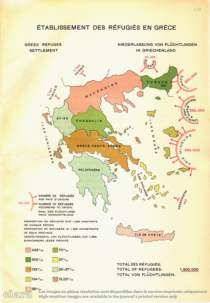

5 The decade of 1912 to 1922 marked a turning point: in 1912, at the end of the Balkan Wars, the region of Macedonia was incorporated into the Greek state. Two years later, in 1915, the First World War further upset the region’s unstable geopolitical balance; the peace treaties that followed were even more disruptive. Already before the Treaty of Sèvres (August 1920) that initiated the dismembering of the Ottoman Empire, favouring Greece’s territorial expansion, the Treaty of Neuilly (1919) obliged Bulgaria to cede Western Thrace to Greece and provided for a voluntary population exchange (Ancel, 1930: 231–49). Greece also controlled Eastern Thrace and the predominantly Greek city of Smyrna and its hinterland, whereas Istanbul was declared a free zone under international protection. With the alleged support of Western Allies (particularly Britain), Greek troops landed at Smyrna in May 1919 and, in 1920, launched an offensive further into Asia Minor which ended dramatically. On 9 September 1922, when the Turkish army entered the city, a devastating fire destroyed the Christian neighbourhoods, causing a massive exodus of 165,000 Greeks and 70,000 Armenians and Europeans. Under the terms of the Lausanne Peace Treaty, Greece returned to its pre-war borders, and was bound to carrying out a population exchange with the newly established Republic of Turkey. [3] In the aftermath of an exhausting war, the arrival of over 1.2 million refugees at the ports of Greece – almost one fourth of the total population at the time – exerted a heavy strain on national resources (Kritikos, 2005: 332).
6 The efforts of international aid organisations were insufficient for dealing with this human wave. Refugees packed Athens, while others occupied every possible shelter on the outskirts of Thessaloniki and most provincial towns where, due to war damage, housing had been in short supply since 1912. The American Red Cross and the Near East Relief Foundation saved many from starvation, but permanent settlement was a far more complicated objective to achieve. Most refugees were received in Northern Greece. In Macedonia, some 640,000 refugees joined 700,000 inhabitants, raising the percentage of the Greek population from 42.6% (1912) to 88.8% (1926) (Aigidis, 1934: 168; Pentzopoulos, 1962: 134).
7 In the summer of 1933, when attending the fourth CIAM meeting with the Italian delegation, Pietro Maria Bardi (1933: 16) reported a conversation with a Greek engineer about the anguish of ten years earlier, adding some demographic figures: in Greece there were 2.6 million inhabitants in 1907 and 5.6 million in 1921; then the 1.2 million refugees arrived.
Colonization policy
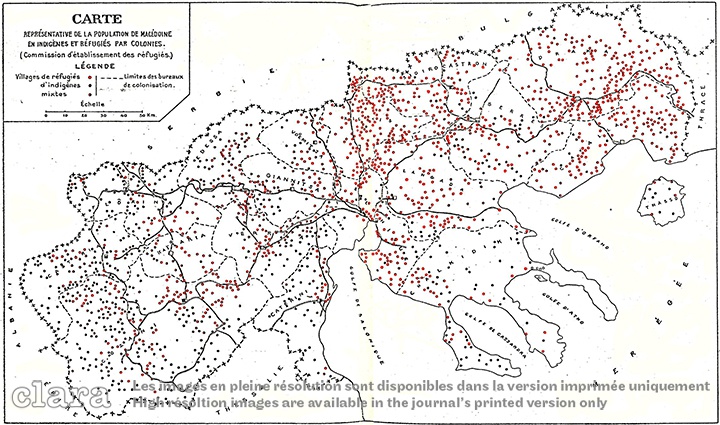
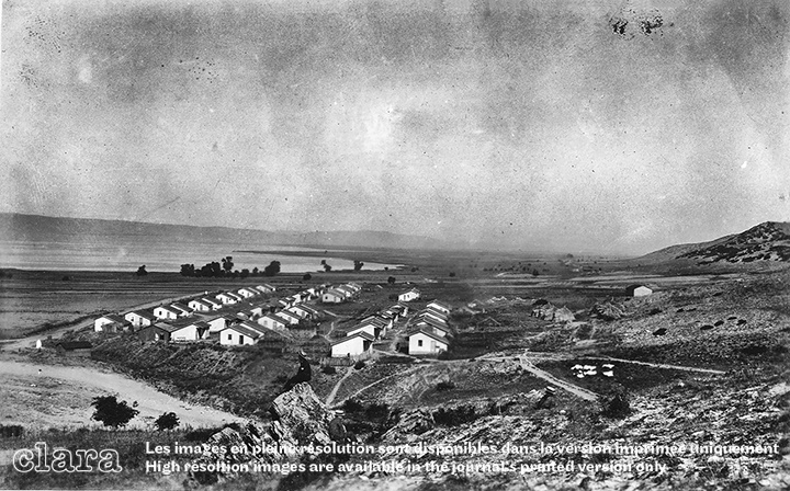
8 In 1922, the Greek government established the Refugee Relief Fund to launch a housing programme and, in 1923, appealed to the League of Nations for economic and technical support. In agreement with the Greek government, the League of Nations established the Refugee Settlement Commission (henceforth RSC), an autonomous supranational body coordinated by an American chairman, a Briton and two Greeks, [4] all of whom were in charge from 1922 to 1930, to administer two foreign loans: £10 million granted in 1924 and £9 million in 1927. The Greek Ministry of Social Welfare took care of urban refugees, while the RSC was mainly responsible for rural settlements. By 1928, 2,085 agricultural colonies (for a total of 145,127 families) had already been established, of which 1,088 in Macedonia (87,084 families), 623 in Thrace (41,828 families), 212 in Crete (4,962 families) and the remaining 162 throughout Greece. Three quarters of them were adjacent to existing villages and the rest were independent. [5] (Fig. 5)
9 When possible, refugees were allocated to sites according to their village of origin in order for them to benefit from existing bonds. Their representatives were first given tours of several districts before choosing a site, and some locations were more sought-after than others. One of the RSC’s main tasks was land distribution. For this the Greek government made available 735,673.5 ha by 1926, of which only 470,154.3 ha were cultivable; some 562,920 ha were in Macedonia and another 116,012 ha in Thrace. Over 70% of this land had belonged to Turkish or Bulgarian farmers who had been forced to leave, and the rest – whether leased or expropriated from large estates – belonged to the state. [6] The number of refugees to settle in a village depended on land amount and quality; land shortages highlighted the need for reclamation works in the plains, to be undertaken after 1925. Refugees were indebted to the state for housing, equipment, and supplies, [7] but most of their debts remained unpaid and were cancelled in the 1940s. In the years that followed, the RSC also strove to maintain existing settlements and prevent the less successful from being abandoned. [8]
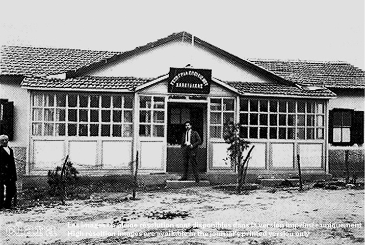
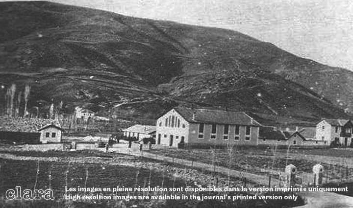
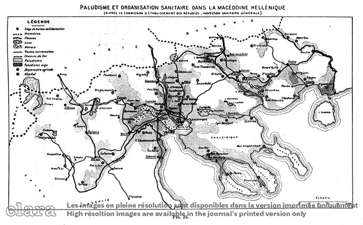
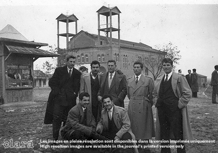
10 According to Prime Minister Eleftherios Venizelos – who had signed the Lausanne Peace Treaty as Greece’s representative – inner colonization in Northern Greece was a matter of national priority, entailing social and economic reforms and active state intervention aimed at a thorough modernization. [9] Water supplies, irrigation and road networks were improved, and health and husbandry stations were established. In Macedonia, the RSC ran the General Directorate of Colonization (henceforth GDCM), headed by Ioannis Karamanos, an Italian-trained agricultural expert. [10] As Sir Hope Simpson (1868–1961, British politician, observer of the 1923 population exchange) emphasized, works began with a genuine exploration of the country, when topographers, agronomists, hydraulic engineers, and builders arrived in the field (RSC, 1930: 16–17) and, together with medical doctors, pioneered the colonization plan envisioned by Venizelos. Moreover, Sir Simpson considered that, for six years, the GDCM acted as a real ministry, employing 1,010 persons (over 50% of the total colonization staff) by 1929, of whom 130 were agronomists, 112 topographers and 112 sanitation officers. The GDCM coordinated seventeen Colonization Bureaus, each serving an adequately sized catchment area with an agricultural station and a dispensary, and fifteen model agricultural and stud farms in Macedonia and Thrace (Hope Simpson, 1929: 588; RSC, 1929). (Figs. 2-4) In fact, Colonization Bureaus also drove the fight against malaria and tuberculosis, initiated in 1925 with the appointment of the physician M. Metallinos, Inspector-General of the Sanitary Service of Colonization in Macedonia-Thrace (Metallinos, 1931). Under his direction, by 1927, Macedonia had a hospital, in Chalkidiki, assisted by the American Women’s Hospitals Association, and 53 dispensaries, each with a pharmacy and serving 900 people. [11] In addition, the RSC reinstated the condotta, [12] an itinerant health-care system used for centuries by the Greek communities of Anatolia and Eastern Thrace (RSC, 1928). (Figs. 6-7)
11 By the end of 1930, the RSC had completed its operations and exhausted its funds. The last report of August 1930 calculated the cost of the entire resettlement plan to be £23,685,470. Of this total, 66.32% was spent in Macedonia and 21.83% in Thrace, while the average expenditure per family was £180. [13] The RSC handed over ongoing services to the Colonization Department of the Ministry of Agriculture, assisted by the newly founded Agricultural Bank of Greece (1929) (Ancel, 1930: 136–8; Kontogiorgi, 2006).
12 In 1926 RSC Chairman Charles Howland reported 116,403 refugee families in Macedonia and another 16,596 in Thrace, who were counted among the total of 147,249 agricultural families in Greece (Howland, 1926: 129). Of the 1,088 colonies established in Macedonia by the RSC, 646 entire villages emerged from scratch, and another 442 neighbourhoods were grafted onto pre-existing villages, while an additional considerable number of refugee families were settled in villages abandoned by exchanged Turks or Bulgarians. [14] (Figs. 8–9)
13 New settlements were usually named after refugees’ places of origin. In the case of existing villages, Greek names replaced Turkish or Bulgarian toponyms, as suggested by specialists from the School of Philosophy of the Aristotle University of Thessaloniki (RSC, 1928b).
14 In 1926, when the process of distribution and settlement of refugees was completed, individual refugees could move only upon authorization by the local Colonization Bureau, and only to join their wider family or their old community established elsewhere. The main criteria for distribution of settlements concerned the refugees’ geographic provenance, common descent, and previous occupation. Thus, refugees from the hinterland of Pontos and the plateaux of Anatolia were settled in mountainous areas, Thracians in plains or valleys, those from the coasts of Asia Minor in the coastlands or in the plains. By 1928, 46,651 rural dwellings were erected (both by the Greek government and the RSC), while 50,532 Turkish and 3,204 Bulgarian exchangeable houses were allocated. To cope with water supply, 365 aqueducts were built; 290 artesian and 416 common wells were dug. By the end of 1928, the teams of topographers had surveyed 718,655 ha of land, of which 94,244 had been distributed in regular parcels. [15]


Land reform
15 The refugee problem emerged before 1922, particularly during the two Balkan Wars and the First World War, when thousands of families living near the borders with Bulgaria and Turkey fled to Greece. In 1917, the Greek Ministry of Agriculture established a special Colonization Department and passed a law allowing expropriation of state, municipal and community lands, church property, estates owned by absentee landlords, or private holdings exceeding 10 ha. Preliminary surveys, mainly in the flooded plains of the Axios and Strymon Rivers, had been carried out during the First World War by special teams of the Allied troops stationed in Macedonia. With the 1923 refugee crisis, land reform could wait no longer, requiring changes to Article 17 of the Constitution and compulsory expropriation of all large estates. [16] From 1917 to 1925, 341 properties in Macedonia were expropriated, some of which was given to landless native farmers and the rest to refugees. By the end of 1927, the amount of land available to the RSC had increased to 616,112 ha in Macedonia and 815,592 ha in all of Greece (RSC,1927).
16 In 1925, the Topographic Departments of the Ministries of Agriculture and Communication began settling refugees based on a rough estimate of available land. The land was provisionally allocated to each village in shares based on a family of four. [17] (Fig. 10) Permanent allotment, however, was made possible only upon survey. In 1927, the Ministry of Agriculture organized a Land Registry Department in charge of surveying and distributing land, parcelling allotment for housing and farming lots, issuing title deeds, and drawing plans and diagrams. The department had its main branches within the GDCM under the RSC administration, and concluded its task in April 1933 (Papastratos, 1935).
17 In 1930, when the RSC was liquidated, a total of 1,261,126 ha had been surveyed all over Greece, 106,710 in Macedonia and 147,000 in Thrace; accordingly, 378,100 ha were allocated in Macedonia and 13,500 ha in Thrace. By 1930, the extension of cultivated and cultivable areas was estimated at 480,000 ha (Notaras, 1934: 27, 48; Kontogiorgi, 2006: 147–8). In the rest of Greece, the extension of cultivated and cultivable land was 55,280.2 ha, of which 43,733.3 ha were cultivated and 11,546.9 ha were cultivable (RSC, 1930: 13). By 1934, 2,036,300 ha of farmland and 1,638 villages were surveyed in Macedonia and Thrace out of a total of 4,238,000, leaving another 223,800 ha and 156 villages to be surveyed. Out of these, 1,384,378 ha had been allocated, leaving 821,000 ha to be distributed. By 1932, housing allotments of 915 villages were completed (Papastratos, 1935: 1016–26).
18 The purpose of land reform was to provide land to both rural refugees and landless native peasants, who were often disputing over property boundaries. Former large estates provided less cause for strife, as natives with little or no land received holdings comparable to those of refugees. Land was classified into categories according to fertility and potential use, thus many farmers received fields in different locations. High population densities resulted in small farm holdings per family, usually 3 to 4 ha in the plain of Thessaloniki and 2 to 3 ha in the plains of Serres and Drama (Kontogiorgi, 2003: 68–9). Land distribution in the plains (as in those of Skoutari and Serres) was more rational, whereas in foothill regions (as at Kato Poroia on the Belles foothills) it became extremely fragmented, hindering mechanization. The RSC organized six agricultural stations – at Thessaloniki, Florina, Naousa, Orestiada, Komotini and Drama (Notaras, 1934: 28) – specialized in the introduction of new crops and techniques, cattle breeding and dairying, poultry rising, and bee and silkworm cultures.
Reclamation works
19 Finally, the Greek government undertook major reclamation works. Most of the lands controlled by the RSC were in the plains of Thessaloniki and Serres-Drama, whose exploitation was hampered by seasonal floods and lack of transport infrastructure. The Strymon River formed vast marshlands in the plains of Serres and Drama, causing summer outbreaks of malaria that were even more deadly in the plain of Thessaloniki due to the combined effect of the Gallikos, Axios and Aliakmon Rivers.
20 Earlier reclamation schemes dated back to the late Ottoman administration when, in 1884, Haci Tahir Bey, a landowner from Serres, hired foreign engineers to drain Kerkini Lake and render the Strymon River navigable. [18] Eight years later, in 1892, the British firm Kinipple & Jaffrey [19] drafted a drainage and irrigation scheme for the central Macedonian Plain, where wealthy entrepreneurs from Thessaloniki had started investing in large agricultural estates. [20] Kinipple & Jaffrey proposed rerouting and embanking the Axios River and draining Giannitsa Lake by digging a ditch. This solution, combined with the construction of levees along the Aliákmon River, reappeared in a Société Française d’Entreprises memorandum addressed to the Greek government in 1919 (Société Française d’Entreprises, 1919; Williams Huntsman, 1937).
21 With the arrival of refugees, large-scale reclamation became a priority. From 1923 to 1925, Greek and German specialists drafted plans for the newly established Office of Hydraulic Works of the Ministry of Communication, which entrusted reclamation works to American firms: the Foundation Company of New York (for the Thessaloniki Plain, 1925), and John Monks & Sons and Ulen & Company (for the Serres-Drama Plain, 1928), with a budget of $17.33 million and $23 million respectively (Arliotis, 1935: 184; RSC, 1929b).
22 Technically, reclamation entailed not only drainage of swamps, but also adjusting the size and shape of riverbanks, opening irrigation canals, and diverting river mouths from commercial harbours. [21] Accordingly, works in the Thessaloniki Plain (covering an extension of 208,000 ha) included embanking the Axios River and rerouting its mouth along with those of the Gallikos and Aliakmon Rivers. Additional works concerned the drainage of Artzan and Amatovo Lakes, channelling water from Giannitsa Swamp and related streams into the new Loudias Canal, while opening another canal encompassing the plain to re-route waters from smaller rivers into the Aliákmon (Papanikolaou, 1927; Williams Huntsman, 1937b–d).
23 Aimed at the reclamation of 156,000 ha, the Strymon scheme entailed a series of dams to control the depth and course of the river and its tributaries, drainage works and new rural roads (Yenidounia, 1927). The north course of the Strymon River was diverted southwards towards Kerkini Lake, and a dam was built to form a basin for excess floodwater. From there, the river, rerouted in a new artificial riverbed, continued southwards, crossed Achinos Lake, passed the Straits of Amphipolis and finally flew into the Gulf of Orfano. Many streams were diverted, draining the Philippi Marshes via a central canal conveying water into the new Angitis riverbed and thence into the Strymon (Theodoridou, 2017). An irrigation network was also to be constructed, along with many new bridges. (Figs. 11-12)
24 The Great Depression of 1929 brought about an intermittent money flow, slowing down the works, which reached completion only in 1934 in Thessaloniki Plain, and after 1940 in the plains of Serres and Drama (Special fund of hydraulic works 1940: 12–13). In 1931, Pietro Lopresti, a graduate of the Padova School of Engineering who had worked on the Pontine reclamation, joined the Greek team from the Office of Hydraulic Works and supervised the implementation of the Strymon scheme (Theodoridou, 2017: 62–87). In March 1932, the League of Nations called upon Natale Prampolini, a leader of the Italian reclamation, [22] to assess works under way and the agricultural potential of the so-called New Lands of Macedonia (Prampolini, 1932; De Angelis, 2015). In 1936, the Ministries of Finance, Agriculture and Communication established the Special Fund for Hydraulic Works in Macedonia, which was in charge of completing the drainage of the plains by 1942.
25 The geography of Northern Greece changed dramatically: by the end of the 1930s some 80,000 ha of marshes and lakes became healthy and fertile, encompassed by earlier refugee villages and field allotments at a short distance from one another (Kontogiorgi, 2006: 292). [23] This fast-paced metamorphosis was paralleled by rural overpopulation and intensification of agriculture. In the 1920s and 1930s, production expanded, becoming less diversified and more market-oriented (Aigidis, 1934: 96–144). In 1928, in an effort to counter rural-urban migration, Prime Minister Elefterios Venizelos launched a wheat self-sufficiency policy similar to Mussolini’s Battaglia del Grano (1925). The same year, the University of Thessaloniki opened its own Department of Agriculture, eight years after the creation of the Higher Agricultural School of Athens in 1920. [24] Agricultural secondary schools and training centres were established in the New Lands (Ploumidis, 2010: 56–7, 118–35). In 1929, the reorganized Ministry of Agriculture and the newly founded Agricultural Bank of Greece supported agricultural studies by establishing a system of grants and loans. By 1933, 40% of Greek farmers had become owners, forming a large conservative class of smallholders [25] which might avert peasant radicalism or potential communism, at a time when, in the USSR, forced collectivization of agriculture was praised as the foundation of a future society.
Housing provision and rural villages
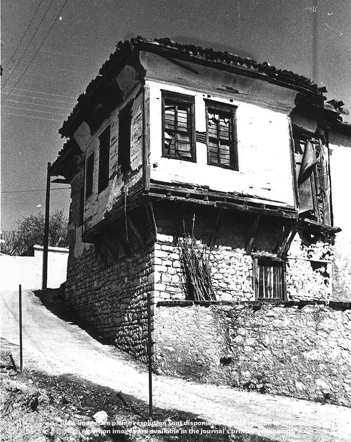
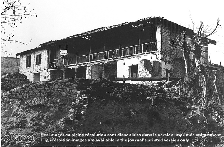
26 The arrival of refugees exacerbated the housing shortage, which was initially caused by extensive war damage. Abandoned Turkish and Bulgarian houses needed major repair and did not suffice. Provisionally, refugees sheltered in tent camps or overcrowded abandoned buildings, then plans were drawn up for villages and several basic housing types, all built primarily with local materials (which in most cases meant mud bricks) (Theodoraki, Theodoraki-Patsi, Theodoraki, 2007).


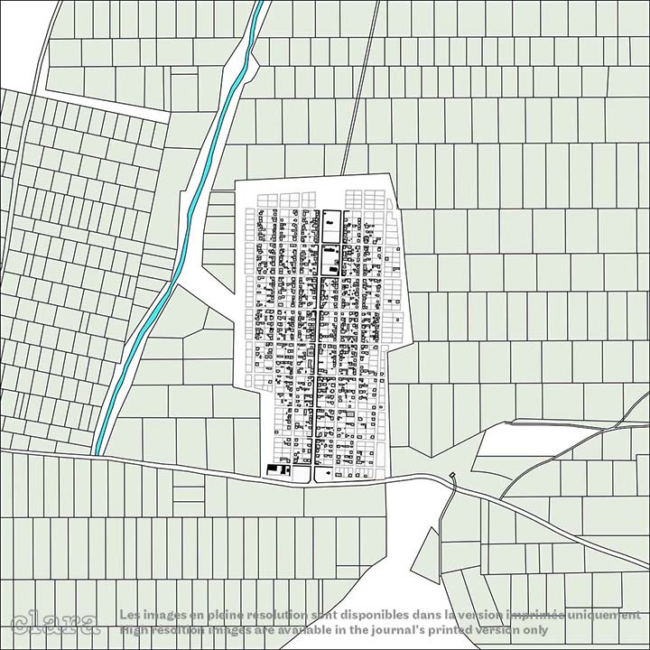
27 The urgency and magnitude of the problem influenced the choice of village layout. The RSC adopted standard functional plans of a simple rationality instead of site-specific solutions. Colonies were located in the flatland and hillsides below 200 m of altitude, exploited existing infrastructure and encompassed lakes and marshes awaiting reclamation. Around the shores of Giannitsa Lake, and on the valley terraces above the Axios River, there were only a few fishing villages, comprised of huts, whose irregular layout stood in stark contrast with the gridiron pattern of the thirty-eight refugee villages along Via Egnatia or on the lower terraces dominating the lake from north and west. (Fig. 13)
Village layouts and land allotment
28 Whether native, mixed, or exclusively refugee, the typical village featured a compact layout surrounded by farmland allotted to settlers, who was often dispersed among various locations according to the quality of land and type of crop. (Fig. 14) RSC Chairman Henry Morgenthau argued that a compact pattern was more appropriate to the Greek rural tradition:
An ‘agricultural community’ in Greece does not mean, as in America, a community made up of farms detached from one another. It means first of all a village, where all the families of that community live side by side. The farmlands lie all about this village. These lands are marked by boundaries and are the private possessions of the various families.
30 The small size and the dispersal of individual farms, however, hampered mechanized farming. In the 1930s, when the problem of maximizing soil exploitation regained momentum due to the completion of reclamation works (Greek Ministry of Finance, 1935), the compact settlement pattern was criticized for the small size and over-fragmentation of farming plots. In 1930, agronomist Epameinondas Kypriadis, [26] director of Applied Agricultural Practices at the Ministry of Agriculture, proposed a revision of the village layout and the distribution of holdings, with a view to adopting mechanized farming and thus increasing productivity (Kontogiorgi, 2006: 313). Taking into consideration the new reclaimed land, Kypriadis suggested to keep the fields of a same holding adjacent to one another, and to locate them near the village. Alternatively, farms and farmsteads could cluster around a small service nucleus. Kypriadis also proposed increasing the size of farm parcels in order to save money and effort and thus make cultivation more effective. Though supported by his fellow agronomists, Kypriadis’s scheme failed to receive parliamentary approval (Kypriadis, 1933: 433–47). (Fig. 15)
31 Most refugee colonies shared a uniform regular layout, whereas pre-existing villages were characterized by a robust maze of narrow, winding streets which contributed to the longevity of single buildings. Under the Greek administration, these defensive measures became obsolete, and were almost an obstacle to emerging transportation needs.
32 In flat or highland areas, however, where abandoned housing was available, refugee settlements retained the original village pattern. Surveyors and agronomists of the Colonization Bureau had previously drawn plans on-site according to the gridiron layout. This rational system could be easily adapted to different sites, always allowing regular building lots. In fact, a special legislative decree specified that each settlement was to be laid out according to a simple plan divided into lots, providing few central, often adjacent, blocks for key community institutions, namely the school and the church (see Article 6 – Housing – in: The Government Gazette, 1923). (Fig. 16)

33 School buildings were not included in the provisions of the colonization policy, yet 266 schools were constructed in Macedonia and another 234 in Thrace. The RSC usually supplied refugees with building materials. Sixty-five villages had a house that served as a school, while a considerable number of colonies built their own schools with help from the Greek government or no assistance at all. Awaiting something better, some communities organized a temporary school under an improvised roof or in a cabin or hut (RSC, 1928: 18; Hope Simpson, 1929). Refugees set up the earliest churches as poor timber structures or small buildings replicating the Anatolian three-apse style. After the Second World War, when economic conditions improved, these were replaced by imposing buildings dedicated to a patron-saint, often with an adjoining community hall. Gradually, villagers established communal facilities, using private lots or houses as shops, workshops for farming equipment, or coffeehouses for social gatherings.
34 An average medium-sized village included eighty blocks, each divided into six or eight lots varying from 500 to 800 m2. The village of Nea Axos, however, featured four plots per block, and Nea Pella’s oblong blocks included twelve plots. (Fig. 17) Street width ranged from eight to thirteen metres. In general, there was a strong correlation between the village layout and surrounding field allotments. New villages at a short distance from one another raised the profile of colonization work, shaping the rural landscape which impressed Sir John Campbell, RSC Vice-Chairman (from January 1924 to January 1927) when he visited Greece in May 1929.
The aspect of the country has entirely changed. Everywhere, one sees the cheerful red roofs of the colonisation settlements. Where formerly vast uncultivated plains stretched, there are now flourishing villages, full of bustling activity, and showing obvious signs of comfort, and in many cases of prosperity. The whole countryside is awake, and alive with new life.
Building refugee dwellings
36 Some refugees found shelter in houses abandoned by Turks and Bulgarians, which were in rather a ruinous condition and needed major repair. Many families were forced by circumstances to occupy an abandoned house as a temporary dwelling. They were settled “without the important advantages which flow from real settlement” (ibid.: 4).
37 From 1922 to 1924, before RSC services became operational, the Greek state built 13,487 dwellings, supplying refugees with building materials and a small sum (₯ 5,000 to ₯ 6,000 [drachmas]) so that they themselves could put in the manpower; where local materials were of a low quality the resulting structures gradually disappeared (RSC, 1930: 11).
38 In 1924, on behalf of the RSC, the League of Nations held an international tender for 10,000 prefabricated rural dwellings. The tender-winning company was Danziger Hoch und Tiefbaugesellschaft mbH (Danzig [27] Building and Civil Engineering Company, or DHTG), founded for the purpose by Adolf Sommerfeld. [28] A master builder and contractor in Berlin, Sommerfeld had seized the outbreak of the First World War as an opportunity to experiment with material-saving prefabrication methods for industrial structures, military halls and troop accommodation. He patented a construction system which layered relatively advanced thermal insulation materials between factory-cut, interlocking timber, and built a prototype prefabricated wooden house.


39 In 1924, for the design and technical management of the mass-housing project in Macedonia, Sommerfeld hired Fred Forbát, [29] a Jewish-born Hungarian architect who had already collaborated with AHAG while also experimenting with building industrialization with Gropius and Meyer (1920–22; see: Colonas, 2003; Seelow, 2018; Tournikiotis, 2019; Forbát, 2019; Hastaoglou-Martinidis and Pallini, 2022).
40 Forbát moved to Thessaloniki, where he could coordinate the assemblage of DHTG kits for the eighty construction sites scattered between Giannitsa (west), Goumenissa (north), Drama (north-east) and Chalkidiki (south). The vast area was divided into six districts, each coordinated by a German foreman. Registered in the Free State of Danzig (see note 27), DHTG was based in Belgrade, where production was handled and technical assistance was provided (Forbát, 2019: 86). Wooden studs were produced in Sommerfeld’s woodworking plants of Schneidemühl (Piła), Dragemuhl, Szczecin and Kolmar in Posen, and shipped to Thessaloniki via Szczecin. Scheduled for implementation between the summer of 1924 and early 1925, the project consisted of three types of standardized timber-framed dwellings. (Fig. 20) The simplest consisted of a single room with a small kitchen (35 m2). The second and third options consisted of a two-room house with a store and a barn (of 45 or 52 m2). The largest type featured better distribution and a symmetrical façade with a setback entrance. [30] (Fig. 21) The contract included construction of timber frames, foundations, and tiling. The Colonization Bureaus would assemble the houses, while refugees would fill in the walls with any available material, taking care of inner and external plastering and the installation of wooden ceilings and floors. Despite delays due to technical and organizational problems, [31] by May 1925 a total of 9,673 timber-frame units were completed: 9,228 in Macedonia and 445 in Thrace. (Fig. 22) Total expenditure amounted to £572,124,3 with an average cost of £55 to £77 per dwelling type. Stephanos Deltas, a former Greek minister and member of the RSC, expressed satisfaction with the new DHTG leadership. Nevertheless, some refugee representatives argued that DHTG workers should be replaced by small Greek contractors. Repeated attacks in the spring of 1925 intimidated the Greek members of the RSC, who allocated all colonization contracts to Greek contractors. In early May, Sommerfeld and Forbát returned to Berlin, leaving only a few DHTG employees to handle the business in Thessaloniki. The DHTG method turned out to be expensive and less adaptable to conditions on site (Notaras, 1934: 65–6). Eventually, the RSC decided to entrust another 42,045 rural dwellings to small local contractors supervised by the Colonization Bureaus’s technical service (RSC, 1925). Thus 21,015 dwellings were erected in Macedonia and 10,982 in Thrace, and an additional 10,048 units in the rest of Greece. (Table 1/Fig. 23)


| Macedonia | Thrace (Drama and Cavalla districts included) | Subtotal | |
| Established families | 87,084 | 42,687 | 129,771 |
| Exchangeable dwellings | 34,222 | 25,683 | 59,905 |
| Dwellings built by Sommerfeld-D.H.T.G. (1924–25) | 9,228 | 445 | 9,673 |
| Dwellings built by the state (1922–24) | 10,313 | 3,174 | 13,487 |
| Dwellings built by the RSC (1925–29) | 21,015 | 10,982 | 31,997 |
| To be built by the RSC (allocated funds) | 634 | 209 | 843 |
| TOTAL | 76,412 | 40,493 | 116,905 |
| Additional dwellings that would need to be built and for which funding was lacking | 8,825 | 3,300 | 12,125 |

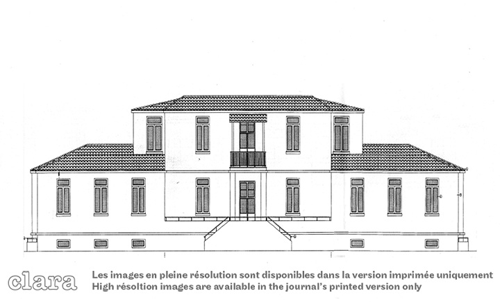
41 The dwelling implemented by the RSC services adopted a similar standardized pattern with different building techniques: masonry foundations and walls, and a tiled roof (Ancel, 1930: 154–7; RSC, 1930). The simplest single-family type covered 49 m2, the two-room house 56 m2 and the biggest one 70 m2. To save on costs, single-family houses were combined to form a semi-detached unit. [32] (Fig. 24)
42 These houses could accommodate larger families and be adapted to the settler’s occupation. Grain farmers needed a stable for their ox (or horse) and a loft for their harvest, fishers a vast shed for their tools and fish, silkworm breeders a room to spread out mulberry leaves, and tobacco farmers a dryer protected from rain and sun. The lot always included room for a vegetable garden. The speed of construction depended on available labour. Since many refugees were unemployed, the RSC allowed them to build their own homes under supervision. They were provided with wood, tiles, nails and money for carpenters and mason wages, but had to take care of their own commuting. Until 1930, the most common construction materials were mud brick and stone. Shortly afterwards, baked brick became readily available. The average house became larger, also due to the improved economic conditions of refugees. The use of standard plans for refugee housing heralded the trend toward architectural uniformity, which replaced the variety of regional styles, which were particularly rich in mainland Greece.
New countryside under construction
43 From 1924 to 1928, prior to the completion of reclamation works, the RSC established 1,088 new villages and new neighbourhoods in existing villages in Macedonia alone. The RSC’s last report (RSC, 1930) recorded a Greece-wide total of 130,934 dwellings made available for rural refugees between 1922 and 1929, at a cost of ₯ 1,001,722,628 (c.£ 3,564,849.2, at a ₯ 281/£ rate). [33] Macedonia and Thrace were home to the vast majority of these dwellings: 116,905 houses for 128,912 rural families. (Table 1) Massive refugee settlement in the New Lands triggered modernization in the building sector, integrating standardization, prefabrication, mass production and rational management. In fact, the experience conducted in the New Lands was intended as a prototype for similar emergencies elsewhere (Kress, 2008: 96–8; Kress, 2011: 129–91).
44 Repopulation of the plains, geared towards commercial agriculture, generated more demand for internal transportation. Roads and bridges, and extension of the port of Thessaloniki, were both a response to and driver of such demand. While mountain villages were gradually abandoned, some rural settlements – Giannitsa and Katerini in Central Macedonia, and Sidirokastron and Irakleia in the Serres Plain – grew into small towns due to their favourable position. In fact, the modernization agenda for the New Lands also addressed medium-sized towns such as Veria, Naoussa, Serres and Cavalla. Most town plans of the 1930s aimed at integrating refugee neighbourhoods and pre-existing nuclei, with a view to fostering local manufacturing. [34]
Old and new villages in Central Macedonia, and vestiges of a distant past
45 The new northern border and the resulting territorial increase – followed by colonization, land reform, drainage, and reclamation – triggered a profound change in the settlement network and hierarchy. Before 1912, most rural villages were relatively autonomous communities, set among foothills for defensive reasons, but also to avoid the harsh climate and unhealthy conditions of the plains. Twenty years later, in the early 1930s, the plains featured a dense settlement pattern: Central Macedonia alone included 509 new rural communities (180,000 people; Ancel, 1930: 151), mostly located in the plain or near Thessaloniki, where new rural villages almost merged with the fifty urban neighbourhoods built on the city’s outskirts and housed over 107,000 refugees. This increase in the Greek Orthodox population accelerated the metamorphosis of this formerly predominantly Jewish city into a Hellenic regional capital (Hastaoglou-Martinidis, 1997; Darques, 2002: 81–88). The establishment of new borders had an impact also on the settlement hierarchy: while northern and eastern connections dwindled, communications with Southern Greece gained momentum. [35] Many provincial towns declined owing to Thessaloniki’s increased attractiveness within the region, which was driven in part by the simultaneous founding of Aristotle University [36] and the International Fair (1926).
46 In the plain of Thessaloniki, several refugee settlements alternated with earlier agricultural estates and vestiges of a distant past. In the foothills of Mount Paiko, Koufalia, Pella, Nea Pella, Giannitsa, Axos and Neos Mylotopos lined the ancient Via Egnatia, the southernmost route across the Balkans. The Ancient Romans had upgraded this military road as an extension of the Appian Way from Dyrrhachium (Durrës) to Bysantium (Istanbul). About 30 km west of Thessaloniki, the Via Egnatia crossed the north-south route of the Axios/Vardar River, reaching the great plains of the Danube basin. [37] This very node attracted the first attempts at colonization and agricultural development in the wake of Ottoman reclamation and railway schemes. [38]
47 The Via Egnatia maintained a strategic role in the 1920s, favouring resettlement operations and the logistics of reclamation, somehow unlocking its functional and symbolic potential for future spatial planning.
48 On approaching ancient Pella, originally an inland port, [39] some Macedonian grave tumuli line Via Egnatia. The Pella archaeological site also lies along the road, to the west of modern Pella, a native village which received 163 refugee families, rising amphitheatrically on the hill just like the ancient fortress it replaced (Leake, 1835: 260–6). (Fig. 18)
49 In contrast, the ruins of the Roman Colony of Iulia Augusta Pella (45–30 BCE) are almost embedded in the regular grid of Nea Pella, which Jacques Ancel (1930: 152) described as a village of thatched cottages for refugees from Tsiflikioi in Eastern Thrace. Nea Pella well epitomizes the hierarchical perpendicular roads forming identical blocks for row upon row of small, identical houses, each with its own backyard. Nea Pella was built along a central road, perpendicular to Via Egnatia, which ascends from the chapel of St Paraskevi (named after the saint depicted on the icon the refugees brought from Tsiflikioi, their village of origin) to the 1940s Neo-Byzantine-style church and its adjacent War Memorial, to the school and, further up, to the football pitch surrounded by fields. (Fig. 19)
50 After just 9 km, we reach Giannitsa, lying at the foot of Mount Paiko. The seat of a Colonization Bureau from 1923, Giannitsa was originally a new town founded by the Ottomans (c.1372) as a bridgehead to the Balkans. [40] Ancel wrote that Giannitsa bore little resemblance to the Turkish town extolled for its vast market and huge caravanserai (Demetriades, 1975). In the late 1920s, some vestiges were still visible on the elongated hill above the plain; to the south, the old city was a sprawl of rubble, a lone minaret still standing. Thracian refugees had replaced Turks and Bulgarians, sturdy planters of tobacco, corn, and vines. The Thracian neighbourhood to the north was made up of white rural houses; a new district of grey workers’ houses was rising towards the south-west. Out of 9,128 inhabitants, 5,383 were refugees, 4,501 of whom were farmers (Ancel, 1930: 193–4). (Fig. 25) In 1926, a memorial was erected at the eastern entrance of Giannitsa along the Via Egnatia, celebrating the liberation from the Turks and the incorporation into the Greek state after the fierce and deadly battle of 20 October 1912. At the top of the memorial’s pyramid is a winged man who writes in the records of history; at the base a dead soldier lies in the arms of Mother Greece (Triantafyllidou, 2022).


Neos Skopos
51 Neos Skopos was established in 1924 for refugees from Üsküp in Eastern Thrace (Skopos in Greek), a prosperous village with a strong tradition in education, which had produced many doctors, poets, and artisans. [41] In 1923, when Üsküp’s inhabitants were forced to leave, the better educated scattered to various cities in Greece and abroad. The peasants, however, formed Neos Skopos, initially designated by the RSC to shelter only 408 families (1,621 individuals and 2,000 cattle), who, by 1933, were joined by 200 additional families from Eastern Thrace. A committee of refugees from Üsküp chose the location for Neos Skopos based on its proximity to Serres (8 km) and the railroad. It was the site of a former çiftlik [42] named Kesislik, a large tract of poorly cultivated land which flooded every year (Yeager, 1979: 357–64; Psathas and Mitrakli-Psatha, 2006: 37–44). Initially, refugees lived in tents and makeshift huts but soon began to build their houses with mud bricks and wood. The village developed gradually over the years: a gridiron layout with regular blocks arranged around a central square. (Figs. 26–28)
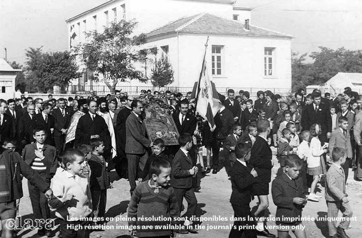
52 Permanent houses of a standard design – a three-room dwelling with a backyard shed – were built with material distributed by the RSC. [43] As early as 1924, settlers built a small, extemporaneous timber church on the village square, which functioned as a school during the week. They built a proper school in 1924–27, using plans and materials provided by the RSC. Designed for the teaching of 230 children, it became the village landmark, standing tall among humble houses. By 1927, with the distribution of farm parcels, the community established essential facilities for a mill, three blacksmiths, two farriers, a tailor, a shoemaker, four barbers, two fabrics stores, a marketplace, ten grocers, seven cafés and a dispensary (Ancel, 1930: 182). After the Second World War, the Skopians who emigrated abroad donated money to construct additional public buildings of a variety rather unusual for a refugee village. In 1950, the new church on the central square was inaugurated, [44] followed by the community hall (1956), the police station (1959), the Orpheus Cultural Centre (1964–66), and the veterinary station (1966). Social clubs [45] played an important part in strengthening and reviving community bonds.
53 An inhabitant recalls the visit of Israeli Premier David Ben Gurion (1886–1973) in November 1950, accompanied by an Italian soil engineer, observing and taking photos from the school balcony. [46]
54 Over time, the main square became home to more infrastructure such as the cinema hall, cafés and taverns, the water tower, and the village hostel. Junior and senior high school premises were established by the government in 1977 and 1985 respectively, on large grounds. In 2008, a folklore museum opened to safeguard historical memory, traditions, and cultural heritage. [47] (Fig. 29–30)
Concluding remarks
55 We explored the steps undertaken by the Greek government and the RSC to settle rural refugees in Northern Greece, including the comprehensive resettlement scheme and specific solutions adapted to address problems as they arose.
56 Most certainly, the Greek refugee crisis may provide new insights into a crucial period for Balkan nation-states, whose newly established boundaries entailed significant multidirectional migrations. This is a subject of international significance that can be compared to Zionist colonization in Palestine, and may inform similar problems in today’s Balkans.
57 The Greek refugee settlement was not only a major programme carried out by the League of Nations in interwar Europe for accommodating large numbers of dislocated people, it was also a major demographic, economic, and social challenge for modern Greece. For the country itself, it represented a pioneering regional policy which combined restructuring the settlement network, extensive land reclamation work, agricultural reform, and building roads and harbours. It was a forerunner to the regional policy projects undertaken after 1960. Within the span of two decades, Northern Greece was radically transformed through a series of political, social, and geographical interventions by the central state. In the rural resettlement programme – disproportionately demanding for the size of the country’s economy – housing was only part of the problem. Agricultural rehabilitation, provision of equipment and supplies, land distribution, training programmes, administration and supervision, community amenities, and provision of public buildings and utilities absorbed the largest share of the total resettlement effort. This trend toward uniformity and interaction with the society at large marked the incorporation of refugees into their new homeland and the fast-paced modernization of Northern Greece. The creation of so many new settlements in mostly remote and less accessible areas was a major national challenge of a largely experimental character.
58 Despite difficult beginnings, the result was cultural homogenization and radical economic and social change within a non-revolutionary political context. Reforms favoured the rapid transition of Northern Greece from a preindustrial society with large estates into a rural society based on small family holdings.
59 Furthermore, the Greek resettlement scheme was broadly relevant as a testing ground for experts from many disciplines: economists and agronomists, sociologists and hydraulic engineers, architects, and planners. In fact, colonization required not just an appropriate technical solution based on a comprehensive understanding of physical features and pre-existing infrastructure, but also, if not mainly, coping with the human factor.
60 The overall scheme, however, cannot be fully understood without considering the shifting role of Thessaloniki from a cosmopolitan port into a regional capital, at a critical time when the city was being rebuilt after the fire of 1917, calling into question heritage in its urban dimension, and in its deeper meaning. Memory and invention become discriminating factors: the collective memory as embedded in the urban space, and new spatial frameworks expressing a future collective projection. The constant tension between the original scheme and the slower consolidation of the urban fabric came to the fore.
61 As opposed to incremental growth, abrupt ruptures urge us to identify which features may also become substantial factors of change. Somehow, rural refugee settlement in the plain of Thessaloniki brought to the fore a correlation between the engineering and hydraulic works in progress and the historical stratigraphy embedded in the region since antiquity.
62 In 1938, L’Architecture d’Aujourd’hui published a special issue on Greece; one richly illustrated article argued that urban infrastructure and tourism development had played the greatest role in modernizing the country as a whole, along with in areas of public welfare, such as education, health, road infrastructure, and … housing for refugees (Sirvin, 1938).

Acknowledgements
An earlier stage of this research was presented at the Promised Lands: Inner Colonisation in Twentieth-Century Mediterranean History ESF Exploratory Workshop (Rome, 7–10 October 2013; see: Fisher, 2014). Further research was carried out in the framework of MODSCAPES–Modernist Reinventions of the Rural Landscape, a collaborative research project funded under the Third Joint Programme of the Humanities in the European Research Area (HERA), dedicated to “Uses of the Past” (2016–20; HERA.15.097). This project has received funding from the European Union’s Horizon 2020 research and innovation programme under grant agreement n. 649307.Under a four and half months research contract at Politecnico di Milano, Derya Erdim has ordered and re-elaborated the iconographic material collected by the authors on the topic and has produced a number of conjectural maps at different scales. Figures 16, 17, 23, and 24 are based on maps held at the municipalities of Palaifyto, Axos, Pella, and Nea Pella. Figure 26 has been produced by reassembling and redrawing the single plans of each main public building – held at the municipality of Neos Skopos – located in and around the settlement’s main square.
Primary sources
Documents from the League of Nations, Refugee Settlement Commission (RSC)
- RSC, 1925. Eighth quarterly report, 5 December.
- RSC, 1927. Sixteenth quarterly report, 15 November.
- RSC, 1928a. Nineteenth quarterly report, 22 Aug.
- RSC, 1928b. Twentieth quarterly report, 21 November.
- RSC, 1928c. List of the refugee settlements in Macedonia with their new names, Thessaloniki.
- RSC, 1929. Twenty-second quarterly report, 27 May.
- RSC, 1929b. Twenty-third quarterly report, 22 Aug.
- RSC, 1929c. Twenty-fourth quarterly report, 6 December.
- RSC, 1930. Twenty-seventh quarterly report, 25 Aug.
Official documents
- THE GOVERNMENT GAZETTE (EFIMERIDA THIS KYVERNISEOS), 1923. Nomothetiká diatágmata Peri agp’stikis enkatastaseos Prosfýgov [Law decree On the rural settlement of refugees], Art. 6 (Housing), (190), 13 July: 1345–8. Retrieved from: https://www.et.gr/api/DownloadFeksApi/?fek_pdf=19230100190 [accessed 23 Mar 2023].
- GREEK MINISTRY OF COMMUNICATIONS AND PUBLIC WORKS, 1958. Leaflet of special service of hydraulic works of Macedonia, Thessaloniki, September.
- GREEK MINISTRY OF FINANCE, HIGH COUNCIL OF FINANCE, 1935. The exploitation of the new lands recovered by the productive works in Macedonia. Experts’ studies and reports [in Greek], Athens.
- SOCIÉTÉ FRANÇAISE D’ENTREPRISES, 1919. Report for an avant-projet concerning irrigation works in the plain of Thessaloniki, 25 October.
- SPECIAL FUND OF HYDRAULIC WORKS IN MACEDONIA, 1940. The productive works in Macedonia [in Greek].
Archival sources
- PRAMPOLINI, N. 1932. Report on the irrigation and drainage works in Macedonia, typescript, Greek translation, Mar. E. Venizelos Archives (Benaki Museum), doc. 183-24.
References
- “Epameinondas Kypriadis (1888–1958)” (1958) [in Greek]. Archive of Economics and Social Sciences, 38(2): 244–45.
- Gefyra (2004) [in Greek]. Gefyra, Cultural Publications of Gefyra.
- La Grèce actuelle (1933). Athens, Ministère des Affaires Etrangères.
- “The government and the refugee commissioners dealt yesterday with all outstanding issues” (1924) [in Greek], Makedonia, 28 December: 1.
- “The history of the AUA” (n.d.), Agricultural University of Athens [webpage]. Retrieved from: https://www2.aua.gr/en/info/history-aua [accessed 12 Aug 2023].
- AIGIDIS, A. 1934. Greece without the Refugees [in Greek], Athens, Alevropoulos.
- ALLEN, H. 1943. Come over into Macedonia. The Story of a Ten-Year Adventure in Uplifting a War-Torn People, New Brunswick, Rutgers UP. https://doi.org/10.36019/9781978810709 (2022 reprint).
- ANCEL, J. 1930. La Macédoine; son évolution contemporaine, Paris, Delagrave.
- ARLIOTIS, D. 1935. “Hydraulic works in Greece” [in Greek], Technikí Epetirís tis Elládos (Technical Yearbook [of the Technical Chamber of Greece]) (1): 278–311.
- ATHANASSIOU, E.; DIMA, V.; KARALI, K.; TOURNIKIOTIS, P. 2019. “The modern gaze of foreign architects travelling to interwar Greece: Urban planning, archaeology, Aegean culture, and tourism”, Heritage, 2(2): 1117–35. https://doi.org/10.3390/heritage2020073
- ATUUL LIMITED n.d. “Fred Forbat”, Architectuul [webpage]. Retrieved from: https://architectuul.com/architect/fred-forbat [accessed 28 Feb 2023].
- BALTA, E. 2014. The Exchange of Populations. Historiography and Refugee Memory, Istanbul, Istos.
- BARDI, P.M. 1933. “Cronaca di viaggio” [“Travel report”, in Italian], Quadrante (5): 5–35.
- BERARD, V. 1900. La Macédoine, Paris, Armand Colin.
- CHATER, M. 1925. “History’s greater trek”, National Geographic Magazine (5): 533–90.
- CHRISTODOULOU, M. 1897. Thrace and Saranta Ekklisies [in Greek], Constantinople, Patriarchate Publishing House.
- CLARK, M. & J. 2021. The Abbott Brothers of Salonica [online]. Retrieved from: http://www.mikesclark.com/genealogy/abbotts_salonica.html [accessed 28 Feb 2023].
- COLONAS, V. 2003. “Housing and the architectural expression of Asia Minor Greeks before and after 1923”, in R. Hirschon (ed.), Crossing the Aegean: An Appraisal of the 1923 Compulsory Population Exchange Between Greece and Turkey, New York, Berghahn Books: 163–78. https://doi.org/10.1515/9780857457028-019
- DARQUES, R. 2002. Salonique au XXe siècle. De la cité ottomane à la métropole grecque, Paris, CNRS Éditions. https://doi.org/10.4000/books.editionscnrs.1311
- DE ANGELIS, D. 2015. Natale Prampolini (1876–1959): L’ingegnere delle bonifiche, Roma, Gangemi.
- DEMETRIADES, V. 1975. “The neighbourhoods and streets of Yannitzà until the end of the 19th century”, Makedonika, 15(1): 160–70. https://doi.org/10.12681/makedonika.611
- DEVEDJI, A. 1929. L’échange obligatoire des minorités grecques et turques, Paris, Imprimerie de Montparnasse.
- ELIEZER, V.I. 2018. “Asher Moses (1899–1975) and 14 May 1948 – Before and after” [in Greek], Alef – Quarterly Publication of the Jewish Community of Athens (70), 21 November. Retrieved from: https://tinyurl.com/49kevb8r [accessed 23 Mar 2023].
- ERCOLE, G. 1922. “En avion, au-dessus de la Thrace” [In the airplane, above Thrace], L’Illustration (4157): 437.
- FISHER, A. 2014. Promised Lands: inner colonisation in 20th-century Mediterranean history: Scientific report. (ESF–European Science Foundation Exploratory Workshop Scheme). https://doi.org/2013/ULB-DIPOT:oai:dipot.ulb.ac.be:2013/163646.
- FORBÁT, F. 2019. Erinnerungen eines Architekten aus vier Ländern [Memories of an Architect across Four Countries], Berlin, Bauhaus-Archiv.
- GEORGIADOU, M. 2004. Constantin Caratheodory: Mathematics and Politics in Turbulent Times, Berlin, Springer. https://doi.org/10.1007/978-3-642-18562-5
- GOUNARIS, B. 1993. Steam over Macedonia, 1870–1912, New York, Boulder & Boulder.
- GRACE’S GUIDE TO BRITISH INDUSTRIAL HISTORY 2022. Walter Robert Kinipple. Retrieved from: https://www.gracesguide.co.uk/Walter_Robert_Kinipple [accessed 19 June 2022].
- GRINNELL MEARS, E. 1929. Greece Today: The Aftermath of the Refugee Impact, Stanford UP.
- HADJIMICHALIS, C.; KALOGIROU, N.; YEROLYMPOS, A. 1988. North-Greek settlements before and after the liberation. Transformations of the urban and regional space, [in Greek; research report], Ministry of Industry, Research and Technology.
- HASTAOGLOU-MARTINIDIS, V. 1997. “A Mediterranean city in transition: Thessaloniki”, Facta Universitatis (4): 493–507. Retrieved from: http://facta.junis.ni.ac.rs/aace/aace97/aace97-04.htm [accessed 23 Mar 2023].
- HASTAOGLOU-MARTINIDIS, V.; PALLINI, C. 2022. “In Greece before the 4th CIAM. Emergency and innovation in the rural colonisation sites”, FAMagazine (62-63): 65–85. https://doi.org/10.12838/fam/issn2039-0491/n62-63-2022/945
- HOWLAND, C. 1926. L’établissement des réfugiés en Grèce, Geneva, Société des Nations.
- HOPE SIMPSON, J. 1929. “The work of the Greek Refugee Settlement Commission”, Journal of the Royal Institute of International Affairs, 8(6): 583–604. https://doi.org/10.2307/3015675
- KARAMANOS, A. (ed.) 2020. Glimpses of Creation in Modern Greece. The Life and Work of Ioannis Karamanos [in Greek], Athens, Papazisis.
- KIEL, M. 1972. “Yenice-i Vardar (Vardar Yenicesi – Giannitsa): A forgotten Turkish cultural centre in Macedonia of the 15th and 16th Century”, in W.F. Bakker, A. van Gemert, J.W. Johan (eds.), Studia Byzantina et Neohellenica Neerlandica, Leiden, Brill: 300–29.
- KONTOGIORGI, E. 2003. “Economic consequences following refugee resettlement in Greek Macedonia, 1923–1932”, in R. Hirschon (ed.), Crossing the Aegean…, New York, Berghahn Books: 63–72. https://doi.org/10.1515/9780857457028-013
- — 2006. Population Exchange in Greek Macedonia: The Rural Settlement of Refugees 1922-1930, Oxford, Clarendon Press. https://doi.org/10.1093/acprof:oso/9780199278961.001.0001
- KRESS, C. 2008. Zwischen Bauhaus und Bürgerhaus. Die Projekte des Berliner Bauunternehmers Adolf Sommerfeld. Zur Kontinuität suburbaner Stadtproduktion und rationellen Bauens in Deutschland 1910–1970 [Between Bauhaus and Bürgerhaus. The projects of the Berlin building contractor Adolf Sommerfeld. On the continuity of suburban urban production and rational building in Germany 1910–70], PhD dissertation, Technischen Universität Berlin, Fakultät VI – Planen Bauen Umwelt. https://doi.org/10.14279/depositonce-2012
- — 2011. Adolf Sommerfeld – Andrew Sommerfield. Bauen für Berlin 1910–1970, Berlin, Lukas Verlag.
- KRITIKOS, G. 2005. “The agricultural settlement of refugees: A source of productive work and stability in Greece, 1923–1930”, Agricultural History, 79(3): 321–46. https://doi.org/10.1525/ah.2005.79.3.321
- KYPRIADIS, E. 1933. “How the exploitation of the drained land should be done” [in Greek], Technical Annals, 3(33): 433–47, 477–9. Retrieved from: http://library.tee.gr/digital/techr/1933/techr_1933_3_33_433.pdf [accessed 23 Mar 2023].
- LABRUM, E.A. 1994. Civil Engineering Heritage: Eastern and Central England, London, Telford. https://doi.org/10.1680/ceheace.19706
- LEAGUE OF NATIONS, 1924. “N° 701: British Empire, France, Italy, Japan, Greece &c. and Turkey. Treaty of Peace, signed at Lausanne, July 24, 1923”, League of Nations Treaty Series, 28(1-2-3-4): 11–113. Retrieved from: https://treaties.un.org/doc/Publication/UNTS/LON/Volume%2028/v28.pdf [accessed 9 Feb 2023].
- LEAKE, W.H. 1835. Travels in Northern Greece, London, Rorwell.
- LAPAVISTAS, C.; CAKIROGLU-BOURNOS, P.; DOCKTER, W. 2019. Capitalism in the Ottoman Balkans: Industrialisation and Modernity in Macedonia, London, I.B. Tauris. https://doi.org/10.5040/9781788316613
- MAGLIVERAS, D. 1987. “Tribute to David Ben Gurion” [in Greek], Chronika, 10(94): 3–13. Retrieved from: https://kis.gr/scanned_small/T094small.pdf [accessed 23 Mar 2023].
- — 2013. “David Ben Gurion and the Greek spirit” [in Greek], Chronika, 36(240): 12–16. Retrieved from: https://kis.gr/files/xronika%20240_B.pdf [accessed 23 Mar 2023].
- METALLINOS, M. 1931. “Commission d’établissement des réfugiés. Colonisation Macédoine-Thrace. Comptes rendus du service sanitaire. Juin 1925 – Décembre 1929”, Archives de l’Institut Pasteur Hellénique, 2(3-4): 397–457.
- MORGENTHAU, H. 1929. I Was Sent to Athens, New York, Doubleday.
- MYLONAS, H. 2012, The Politics of Nation-Building. Making Co-Nationals, Refugees and Minorities, Cambridge UP. https://doi.org/10.1017/CBO9781139104005
- NOTARAS, M. 1934. The Rural Settlement of the Refugees [in Greek], Athens, Chronika Press.
- ORPHEUS CULTURAL SOCIETY [SYLLOGOS NEOU SKOPOU O ORFEUS] (n.d.) “[About] Skopos in Thrace”, Orfeus [webpage]. Retrieved from: https://tinyurl.com/5n6j68tk [accessed 28 Feb 2017].
- PAPANIKOLAOU, D. 1927. “The Hydraulic Works of the Plain of Thessaloniki” [in Greek], Erga (58): 249–255.
- PAPASTRATOS, C. 1935. “Land survey works of the rural settlement in Macedonia and Thrace” [in Greek], Technical Annals, 8(95-96): 976–1033, 1075–6. Retrieved from: http://library.tee.gr/digital/techr/1935/techr_1935_8_95_96_976.pdf [accessed 23 Mar 2023].
- PARK, S. 2014. “Forbát, Fred (bis 1915: Füchsl, Alfred)”, KIT – Karlsruher Institut für Technologie [webpage]. Retrieved from: https://kg.ikb.kit.edu/arch-exil/312.php [accessed 28 Feb 2023].
- PENNAS, P. 1976. “Strymon and the productive works of the valley of Serres in the Ottoman era” [in Greek], Serraïka Chronika (Serres Annals), 7: 91–114. Retrieved from: http://apothesis.teicm.gr/xmlui/handle/123456789/2924 [accessed 23 Mar 2023].
- PENTZOPOULOS, D. 1962. The Balkan Exchange of Minorities and its Impact upon Greece, Paris, Mouton. https://doi.org/10.1515/9783112415863
- PLOUMIDIS, S. 2010. Land and Memory in the Balkans: ‘Agrarian Nationalism’ in Greece and Bulgaria (1927–1946) [in Greek], Athens, Pataki.
- POLYZOS, N. 1947. Essai sur l’émigration grecque. Étude démographique, économique et sociale, Paris, Recueil Sirey. Retrieved from: https://gallica.bnf.fr/ark:/12148/bpt6k3337492x [accessed 23 Mar 2023].
- PSATHAS, A.; MITRAKLI-PSATHA, V. 2006. Neos Skopos of Serres, Eastern Macedonia [in Greek], Neos Skopos.
- SEELOW, A.M. 2018. “The construction kit and the assembly line - Walter Gropius’ concepts for rationalizing architecture”, Arts, 7(4), 95. https://doi.org/10.3390/arts7040095
- SIRVIN, P. 1938, “Grèce”, L’Architecture d’Aujourd’hui, 9(10): 56.
- THEODORAKI, A.-M.; THEODORAKI-PATSI, J.; THEODORAKI, P.-C. 2007. “Authenticity versus hybridity in rural Greece”, Sustainable Development and Planning III 102: 261–272.
- THEODORIDOU, L. (ed.) 2017. The Diversion of Strymon River. The Great Reclamation Works of the Interwar Period [in Greek], Serres, TEI of Central Macedonia Publishing service. Retrieved from: http://emeiserron.gr/?page_id=335 [accessed 23 Mar 2023].
- TOURNIKIOTIS, P. 2021. “Fred Forbat in Greece. Thessaloniki, Athens, Olympia”, in A. Giacumacatos, S. Georgiadis (eds.), Bauhaus and Greece, Athens, Kapon: 234–38.
- TRIANTAFYLLIDOU, M. 2022. “The Memorial of the Battle of Giannitsa” [in Greek], Philippos (109): 61–84.
- VOUTÌRA, E. 2003. “When Greeks meet other Greeks: Settlement policy issues in the contemporary Greek context”, in R. Hirschon (ed.), Crossing the Aegean…, New York, Berghahn Books: 145–59. https://doi.org/10.1515/9780857457028-018
- WILLIAMS HUNTSMAN, B. 1937a. “The Salonica Plain reclamation works” [in Greek], Technical Annals, 12(137): 823–31. Retrieved from: http://library.tee.gr/digital/techr/1937/techr_1937_12_137_823.pdf [accessed 23 Mar 2023].
- — 1937b. “The Salonica… (part 2)” [in Greek], Technical Annals, 12(138): 875–80. Retrieved from: http://library.tee.gr/digital/techr/1937/techr_1937_12_138_875.pdf [accessed 23 Mar 2023].
- — 1937c. “The Salonica… (part 3)” [in Greek], Technical Annals, 12(139): 949–51. Retrieved from: http://library.tee.gr/digital/techr/1937/techr_1937_12_139_949.pdf [accessed 23 Mar 2023].
- — 1937d. “The Salonica… (part 4)” [in Greek], Technical Annals, 12(140): 1015–22. Retrieved from: http://library.tee.gr/digital/techr/1937/techr_1937_12_140_1015.pdf [accessed 23 Mar 2023].
- YEAGER, R.M. 1979. Refugee settlement and village change in the district of Serres, Greece, 1912–1940, PhD dissertation, University of California, Berkeley.
- YENIDOUNIA, T. 1927, “The hydraulic works in the Strymon Plain” [in Greek], Erga (40): 371–379.
Publisher keywords: mass housing, modern rural villages, Northern Greece, refugee settlement, standardisation
Uploaded: 02/15/2024
https://doi.org/10.3917/clara.008.0140